Solar Eclipse Turns Sun Into ‘Ring of Fire’ This Week


The moon will block the sun in a potentially spectacular solar eclipse this week — a celestial event that will transform the sun into a cosmic “ring of fire” in the daytime sky.

The ring-shaped solar eclipse, known as an annular eclipse, will occur Thursday and Friday (May 9 and 10)  Eastern time. Weather permitting, the eclipse will be visible in certain parts of Australia and the , where the local time will be Friday.

“Solar eclipses can be inspirational to students and others, so it is interesting to have everyone view the eclipse, but only safe methods of viewing should be used,” Jay Pasachoff, an astronomer at Williams College and chair of the International Astronomical Union‘s working group on eclipses, said in a statement. [See Spectacular Photos of a ‘Ring of Fire’ Solar Eclipse]

While nearly 95 percent of the sun will be covered by the moon at the eclipse’s peak, the sky will not be noticeably darker to the naked eye at any point, explained Williams College officials in .

For this reason, special protective lenses, camera and telescope filters and other methods of protection should be used in order to safely watch the eclipse even during full annularity, when the sun is silhouetting the moon.

The path of annularity passes through parts of , , and Western Australia, the and Queensland in Australia. Other nearby parts of the world will be able to see a partial solar eclipse, if weather permits.
more

Thousands flee Calif. wildfires; naval base threatened


LOS ANGELES — A fast-growing wildfire along the Pacific Coast Highway northwest of that has already forced thousands of residents to flee the area jumped the roadway Friday morning, threatening parts of a premier U.S. naval installation.

Firefighters on the scene radioed that , which is backed up to the , should be advised that flames had leapt the iconic coastal highway that was the only barrier beween the fire and the facility.

The base said on its  that the airfield at remained open on a mission-essential basis and had not been evacuated, but base personnel were advised to stay indoors. Photos on the site showed smoke beginning to darken the skies at midmorning, but had not yet affected the housing area.

Kimberly Gearhart, public affairs officer at the base, issued a statement on Facebook page, but did not confirm that the fire had jumped the Pacific Coast Highway (PCH): “The base is NOT in immediate danger from the fire. If/when it crosses PCH, it will be far down the coast from NBVC Point Mugu,”

The naval base, with a population of more than 19,000 personnel, operates two runways, a sea-test range and deep-water port.

More than 10,000 acres of rugged, brush-covered terrain have been burned by the fire that began during the morning rush hour near the major highway and commuter route into Los Angeles’ San Fernando Valley on Thursday.

Thousands of people have fled the area as the wildfire, which has damaged 15 homes, threatened 2,000 more and 100 businesses in its race toward .

Early Friday morning, the blaze was still raging and about 10% contained, local fire officials reported. Forecasters say winds gusting to 45 mph will hit Friday morning but taper off in the afternoon and cooling may begin by evening.

Tom Kruschke, fire spokesman, said there is effectively a vast field of coals behind the flaming edges of the wildfire that could flare up when winds return.

“We’re going to be at Mother Nature’s mercy,” Kruschke said.

He said high winds, high temperatures, low humidity, plus dry vegetation from the winter drought “adds up to a perfect storm for wildfire.”

, a school with nearly 5,000 students that opened in 2002, was evacuated. The Ventura County Fire Department said it had sent 20 fire engines to the campus to protect buildings as flames approached apartments on the eastern edge of the university campus.

full

weekend world headlines

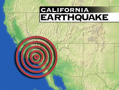
Russian Military Warns Of Potential Catastrophic Quake On US West Coast


Russian Ministry of Defence (MOD“urgent bulletin” being sent to all Russian naval forces operating in the region is warning that there is a“moderate to high” likelihood of a “significant seismic event” ready to occur on the North American Plate, particularly on the Western coastal regions of The , Canada or Mexico.

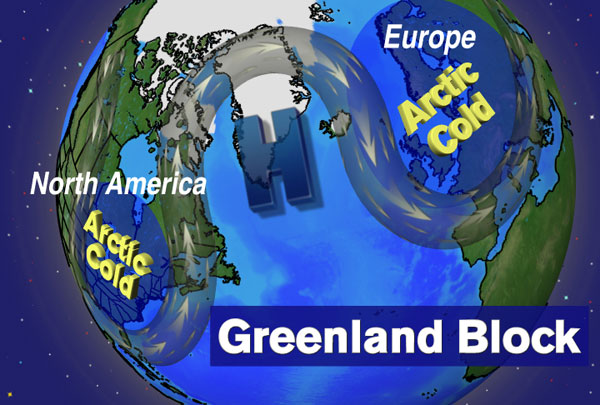
According to this bulletin, Russian military scientists have become increasingly concerned over the past fortnight of the events occurring with the Arctic Oscillation (AO) which has plunged nearly the entire Northern Hemisphere into harsh cold conditions and which Western scientists are blaming on melting sea ice which, they report, hit a record low this past autumn.

Of greatest concern, this bulletin continues, is the massive anticyclone that has formed over  bringing to our planet the highest barometric pressure ever recorded in human history, and which American scientists warned last year would intensify.

American scientists this past week confirmed their Russian counterparts findings, and as we can read, in part, as reported by the Washington Post News Service in their article titled Record Blocking Patterns Fueling Extreme Weather which says:

“A near-record low value of the Arctic Oscillation– the climate index that measures the difference in relative pressure between the Arctic and mid-latitudes – is partly responsible for the unseasonable chill. Just how low has the AO tanked? The AO index plummeted to -5.6 on Wednesday, a historically low value.

One more remarkable aspect of this major league block: observations over Greenland are threatening to break the worldwide record for highest barometric pressure of 1083.3 mb, set on Dec. 31, 1968 in Siberia.”

Most ominous, however, in this bulletin is its blaming this massive anticyclone for the 20 March earthquake swarm occurring under it on the Reykjanes Ridge portion of the Mid-Atlantic Ridge (MAR).

Russian military scientists say in this bulletin that the earthquakes being caused by this massive anticyclone are destabilizing the Eurasian and North American Plates causing a sort of “chain reaction effect” which will ultimately manifest in the rupturing of the Pacific Plate.

As evidence of this potentially catastrophic earthquake event occurring, this bulletin continues, Russian scientists point to the 26 March 5.8 magnitude quake that struck Oaxaca, Mexico, and which they claim “exactly correlates” with their previous findings on the causes and effects of weather pressure induced seismic events.

Virtually unknown to the vast numbers of Westerners are the numerous studies, and their findings, lending credence to Russian research on weather related seismic events, and as we can read as reported by the New York Times News Service in their article titled How Storms Can Trigger Earthquakes which, in part, says:

“Scientists are increasingly pointing to storms as a trigger for earthquakes and mudslides. That’s raising questions about the effects that climate change might have on one of the world’s deadliest natural catastrophes, and to what extent, if any, insurers and governments could be adapting to the interplay between atmosphere and earth.

So far, those answers are as mysterious as the timing of earthquakes, a question that has baffled humans — and killed them — for generations. But recent findings suggest that some linkage exists to increasingly powerful storms.

New evidence shows that atmospheric low pressure systems can prompt the landslide to lurch downward. Pressure drops when warm daytime air results in low “tides,” or when fast-moving storms race onto the scene. The effect on landslides and earthquakes only occurs when the pressure plummets suddenly, causing underground water and air to shoot toward the surface.

That reduces friction between grinding subterranean plates, or under a landslide that’s been held immobile by abrasive dirt and rocks.

“Slides, earthquakes, glaciers, volcanic eruptions — all of these things involve soil sliding on soil, or rock sliding on rock,” explains William Schulz, a research scientist at the U.S. Geological Survey and the author of a study published this month in the journal Nature Geoscience. “And sliding is resisted primarily by one thing, and that’s friction.”

The same conclusion was reached by scientists in Taiwan this June. A study published in the journal Nature described how low pressure accompanying typhoons sparked small earthquakes along the fault between the Philippine Sea Plate and the Eurasian Plate. The scientists note that they make “a definitive connection between fault slip and changes in atmospheric pressure.”

Importantly, both studies say weather impacts can accelerate an earthly act that was bound to happen sooner or later. In other words, low pressure is not the cause of an earthquake, just the trigger.”

To if this massive and historical anticyclone over Greenland will, indeed, prove to be such a seismic “trigger” the Russian Navy is warning about in this bulletin it is not in our knowing…other than to note that anyone living in such an area should always be prepared for the worst happening in any event.

original link sorcha fall

Shocking Find In Mariana Trench


An international research team announces the first scientific results from one of the most inaccessible places on Earth: the bottom of the located nearly 11 kilometers below sea level in the western Pacific, which makes it the deepest site on Earth.

Their analyses document that a highly active bacteria community exists in the sediment of the trench – even though the environment is under extreme pressure almost 1,100 times higher than at sea level.

The Mariana Trench or Marianas Trench is the deepest part of the world’s oceans. It is located in the , to the east of the Mariana Islands. The trench is about 2,550 kilometers (1,580 mi) long but has an average width of only 69 kilometers (43 mi). It reaches a maximum-known depth of 10.911 km (10,911 ± 40 m) or 6.831 mi (36,069 ± 131 ft) at the , a small slot-shaped valley in its floor, at its southern end, although some unrepeated measurements place the deepest portion at 11.03 kilometers (6.85 mi).

Location of Mariana Trench
File:Marianatrenchmap.png
Credit: WikipediaIn fact, the trench sediments house almost 10 times more bacteria than in the sediments of the surrounding abyssal plain at much shallower water depth of 5-6 km water.

Deep sea trenches are hot spots

Deep sea trenches act as hot spots for microbial activity because they receive an unusually high flux of organic matter, made up of dead animals, algae and other microbes, sourced from the surrounding much shallower sea-bottom. It is likely that some of this material becomes dislodged from the shallower depths during earthquakes, which are common in the area. So, even though deep sea trenches like the Mariana Trench only amount to about two percent of the World Ocean area, they have a relatively larger impact on marine carbon balance – and thus on the global carbon cycle, says Professor Ronnie Glud from Nordic Center for Earth Evolution at the .

The Pacific plate is subducted beneath the Mariana Plate, creating the Mariana trench, and (further on) the arc of the Mariana islands, as water trapped in the plate is released and explodes upward to form island volcanoes.
File:Cross section of mariana trench.svg
Credit:  WikipediaRonnie Glud and researchers from Germany (HGF-MPG Research Group on Deep-Sea Ecology and Technology of the Max Planck Institute in Bremen and Alfred Wegener Institute in Bremerhaven), Japan (), Scotland (Scottish Association for Marine Science) and Denmark (University of Copenhagen), explore the deepest parts of the oceans, and the team’s first results from these extreme environments are today published in the widely recognized international journal Nature Geoscience.

Diving robotOne of the team’s methods was to measure the distribution of oxygen into these trench sediments as this can be related to the activity of microbes in the sediments. It is technically and logistically challenging to perform such measurements at great depths, but it is necessary in order to get accurate data on rates of bacterial activity. “If we retrieve samples from the seabed to investigate them in the laboratory, many of the microorganisms that have adapted to life at these extreme conditions will die, due to the changes in temperature and pressure. Therefore, we have developed instruments that can autonomously perform preprogrammed measuring routines directly on the seabed at the extreme pressure of the Marianas Trench”, says Ronnie Glud. The research team has, together with different companies, designed the underwater robot which stands almost 4 m tall and weighs 600 kg. Among other things, the robot is equipped with ultrathin sensors that are gently inserted into the seabed to measure the distribution of oxygen at a high spatial resolution.

“We have also made videos from the bottom of the Mariana Trench, and they confirm that there are very few large animals at these depths. Rather, we find a world dominated by microbes that are adapted to function effectively at conditions highly inhospitable to most higher organisms”, says Ronnie Glud.

The remaining “white spots”

The expedition of the Mariana Trench took place in 2010. Since then, the research team has sent their underwater robot to the bottom of the which is approximately 9 km deep, and later this year they are planning a dive in the world’s second deepest trench, the 10.8 kilometers deep Kermadec- near Fiji in the Pacific.

“The deep sea trenches are some of the last remaining “white spots” on the world map. We know very little about what is going on down there or which impact the deep sea trenches have on the global carbon cycle as well as climate regulation. Furthermore, we are very interested in describing and understanding the unique bacterial communities that thrive in these exceptional environments. Data from multiple deep sea trenches will allow us to find out how the general conditions are at extreme depths, but also the specific conditions for each particular trench – that may experience very different deposition regimes. This will contribute to our general understanding of Earth and its development, says Ronnie Glud.

See the article “High rate of microbial carbon turnover in sediments in the deepest oceanic trench on Earth” in Nature Geoscience.  Link: http://dx.doi.org/10.1038/NGEO1773